In
early May of 2013, daughter Diana posed the question, “Where are we
going on our next trip.” At the time I was busy preparing for a
family reunion by reviewing some family background information
provided over the years by family members. This background consisted
of memories provided verbally by my mother and written down by family
members, an outline of my families history from the earliest member
(John Fox Price) to settle in Tennessee and some sketchy information
purporting to trace his lineage back to an early colonist (also named
John Price) who came from Wales in the early 1600s.
Although
I have always enjoyed history, I have never been very interested in
genealogy. It just seems to me that we are who we are and who are
ancestors were doesn't really change that. Nevertheless, on finding
that a connection to the early Prices of Virginia had been accepted
based on very skimpy evidence, I investigated further.
I
found that most of the information given to me on early family
ancestry in America had been derived from a book by a Rev. Benjamin
Luther Price published in 19201.
This book provided information relating to John Price who arrived in
Virginia from Wales before 1920 and his descendants in Virginia.
However, the book did not trace the family to the John Fox Price who
arrived in Tennessee in the early 1800s, supposedly the first of our
family to settle there. Further work did disclose additional
information which satisfied me that there was a valid link to the
descendants of the earlier John Price in Virginia.
This
limited effort reinforced my belief that spending a lot of time on
personal genealogy was not worth the effort. On the other hand, I
had now developed an interest in learning more about the country that
produced that early American colonists, so I told Diana that I wanted
to visit Wales. Now relieved of the tedium of tracing individual
persons from generation to generation, I started reading about Welsh
history in general and the origin of the Welsh people.
In
his book, A History of Wales, historian John Davies writes that “once
upon a time, the Welsh knew when their history began.2”
They accepted the circa 1136 account of their early British history
written by Geoffrey of Monmouth3,
second bishop of St. Asaph4,
and author of The
History of the Kings of Britain. He
wrote that the first humans to settle in Britain were descendants of
Aeneas of Troy. The same Aeneas who, in Greek mythology, was the son
of Aphrodite5.
Geoffrey wrote that Brutus, a descendant of Aeneas who escaped when
Troy fell to the Greeks, had three sons, Locrinus, Camber and
Albanactus, who created England, Wales and Scotland respectively6.
A
recent more scholarly explanation presented by Stephen
Oppenheimer, titled Myths
of British ancestry,
was published in the October 21, 2006 edition of Prospect
Magazine.
Oppenheimer says that according to genetic analysis, the original
genetic stock for Wales came from Basque hunter gatherers who arrived
between 15,500 and 7,500 years ago. This would have been “after
the melting of the ice caps but before the land broke away from the
mainland and divided into islands7.”
He
claims that this separation from the mainland has preserved the
ice-age genetic stock of southwestern Europe which the people of the
British Isles share “most
closely with the former ice-age refuge in the Basque country.”
Oppenheimer indicates that these settlers may have spoken a language
related to the Basque
language.
He
goes on to say
that genetic analysis further shows that southern England has
received about one-third of its population since the hunter-gatherer
period. Percentages received in other regions are: Ireland 12%,
Wales and Cornwall 20% and Scotland 30%8.
He
writes that Celtic languages were likely spread by agriculturalists
from Anatolia about 7,000 years ago who traveled along the
Mediterranean “to Italy, France, Spain and then up the Atlantic
coast to the British Isles. There is a dated archaeological trail for
this. My genetic analysis shows exact counterparts for this trail
both in the male Y chromosome and the maternally transmitted
mitochondrial DNA right up to Cornwall, Wales, Ireland and the
English south coast9.”
According to Davies, in AD 4810
the Romans, having already occupied the south and east of the island,
reached the River Dee (Afon Dyfrdwy) and received the submission of
the Decangli (a Welsh tribe). But subjugation of the Welsh turned
out to be a long, costly effort which was not accomplished until
around AD 7911.
Roman rule in Britain came to an end in about AD 410.12
During the years between AD 400 and
AD 600, according to Davies, “the main kingdoms of Wales” were
established and Brythonic was transformed “into a language which
can be recognized as Welsh”13
He writes that it was also the period when Wales was pervaded by
Christianity14.
Meanwhile, the Welsh retained their
separateness, as demonstrated by the construction of Offa's Dyke
during the reign of Merca's King Offa (AD 757 – AD 796). The dyke
was not fortified, but was rather meant to define the border between
English Mercia and Wales.15
The Viking presence in Wales was not
as extensive as in England. Although it apparently began around 800
and seems to have continued until around 1150, the Norsemen were
unable to develop large settlements and kingdoms as they did in
England and elsewhere in the British Isles16.
The BBC Wales History site, however, indicates that they “did
settle “in South
West Wales areas including St David's, Haverfordwest and the Gower.”
Meanwhile,
the Viking invaders were also menacing large parts of Europe,
including the colonization of a part of France, which became the
Duchy of Normandy under the Viking leader, Rollo, in 91117.
In 1066 William the Bastard, Duke of Normandy, invaded England,
seized the crown and became its first Norman King, William I.
Although the Normans became masters of England in a few years, Wales,
less centralized, was more resistant, eventually becoming divided
between the Norman Lords of the March18
and the native rulers from the old royal lines19.
Wales was not firmly under the rule of the English King until 1485
when Henry Tudor (Henry VII), of English, Welsh and French royal
lineage, became king.
About
100 years later, in 1494, a John Price was born in Newtown,
Montgomeryshire, Wales. Although the identification is based on
sketchy and unverified information he is apparently my earliest known
ancestor. He married a Florence Clunn and is said to have been the
Great Great Grandfather of the John Price who emigrated to the
Virginia Colony in the early 1600s. From that point, the line of
succession is fairly well documented20.
Diana and I (mostly Diana) had done
some minimal planning for the trip. Neither of us was interested in
any detailed genealogical work. We just wanted to get a look at the
area where our distant ancestors lived and then enjoy traveling in a
country that was foreign but still familiar to us.
Although I had earlier toyed with
the idea of traveling by Amtrak to meet Diana in Washington, DC, I
quickly ruled that out based on the expense of a March Amtrak trip.
Instead I took the Arizona Shuttle to Phoenix on 1 May, stayed
overnight at the Airport Best Western and took a United flight to
Washington National Airport in DC. From there I took a taxi to
Diana's office and rode home with her to spend the night. The next
day we took a car to Dulles Airport and then flew on United to
Dublin, Ireland.
 |
| Bright red door |
We
had a nine hour layover in Dublin and took the opportunity to see the
sights of the city. A short bus ride brought us to downtown and we
set out on foot to explore the city. One of the first things to
draw our attention was a bright red door (right).
Placed in a wall painted a neutral tone and set off with bright
white trim, it presented a quite attractive appearance.
Turning
our attention from the red door we found ourselves looking down a
narrow street with spacious sidewalks, lined on both sides by shops
and set off at the end by St Ann's Church.
 |
| Anne Street South, ending at St. Ann's Church of Ireland |
 |
| National Museum of Archaeology |
Diana wanted to visit the National
Museum of Archaeology, but it was a bank holiday and the museum (left)
was closed.
We next headed to St. Stephen's
Green Park where we expected to enjoy a few minutes of quiet in a
peaceful setting. We approached the park from the northeast corner
where we found two sculptures created by Edward Delaney in 1967.
 |
| Wolfe Tone |
The first of these (right)
commemorates Wolfe Tone, a leading Irish revolutionary figure who
died in a British prison while awaiting execution. The second
sculpture (below, left), located just on
the other side of the wall shown behind the Tone statue, commemorates
the Great Famine of 1740-1741.
 |
| The Great Famine |
As an aside, I later learned that
Wolfe Tones son, William Theobald Wolfe Tone, served as a Lieutenant
in the French Army, emigrated the the United States after the defeat
of Napoleon, and was commissioned a Captain in the US Army.
St. Stephens Green was indeed a
peaceful place, even considering the increased numbers of visitors on
this bank holiday. Most holidayers seemed more interested in the
commercial delights of the streets, with just a few strollers
enjoying the park.
 |
| Peaceful scene in St. Stephens Green Park |
 |
| Sculpted street light |
At the time of our visit a campaign
to elect Members of the European Parliament (MEPs) was in full swing.
Campaign posters, very similar to those seen at home, adorned every
lamppost. The poster in the foreground below supports a Socialist
who opposes, among other things, compulsory health insurance. It
reminded me of some of the rants against “Obamacare” in the
United States and I wondered what the term “compulsory health
insurance” really meant in Ireland and what the European Parliament
might do about it. But, being a guest in the country and short of
time at that, I didn't ask.
 |
| Political signs for the upcoming European Parliament election |
When we arrived at the corner of
Suffolk and Grafton Streets, we found that the Molly Malone Statue
had been temporarily removed to allow for the construction of a
streetcar line. It was
 |
| Molly Malone |
Heading next to Dublin Castle, we
came upon the below scene and paused to take a photograph. I am not
altogether sure just what grabbed our attention. Perhaps it was the
contrast between the ornate building housing the Dublin Tourism
Information Center at left and the three plain, but multicolored,
buildings centered by Louis Copeland Outfitters lined up along
Wicklow Street in the background. Then again it could have been the
colorful blue door and the seemingly misplaced statue just to its
right contrasted with the unexpectedly drab utility building with a
single parked car.
 |
View from St Andrews Street in Dublin looking south toward buildings
on Wicklow Street
|
While we were photographing the
scene, an Irish gentleman, probably in his sixties, with a new camera
stopped to ask what caused us to be interested in that particular
scene. He seemed quite sincere and Diana explained what had drawn
our interest. He then decided to take a photograph himself and it
turned out that he was still learning to use his camera. He was most
pleased when Diana offered to give him a few operating tips.
 |
| Medieval Dublin Castle |
We left the Irish gentleman happily
playing with his camera and continued on our way to Dublin Castle.
We learned that a Viking fortress stood on the site around 930. The
Vikings were defeated by the Irish in 1014 who were in turn defeated
by the Normans in 1169. Each in turn had some sort of fortification
at the site. In 1204, King John ordered the erection of a strong
castle on the site to protect the city. This was completed in 1230.
According to information posted at the site, the Great Courtyard
(upper castle yard) of today corresponds closely with that castle
(right).
Two of the features that interested
us were the gates of Fortitude and Justice shown in the following
photographs.
 |
| Gate of Fortitude |
 |
| Gate of Justice |
After leaving the castle we made a
quick stop at Christ Church Cathedral and then headed back to the
airport. We wanted to get there in time to clear security and eat
dinner before boarding the flight to Cardiff.
The hour and ten minute flight to
Cardiff was on an ATR 42/72 a French-built, short haul turboprop
aircraft capable of carrying 78 passengers in single class
configuration. It was operated by Aer Arann, a regional airline
based in Dublin. Although we did fly across the Irish Sea to Wales,
most of the flight was actually over land along the coast of Wales.
As we descended on the approach to
Cardiff, we noted fields of bright yellow interspersed among the
normal green. We found out later that it was fields of rape (a plant
in the mustard family). Rapeseed is used in the production of animal
feed, vegetable oil and biodiesel. Canola (with “can” referring
to Canada and “ola” referring to oil) is a form of rape developed
in Canada in the 1970s. It has less erucic acid, making it better
suited for human consumption. We learned that it was first grown in
Wales (and probably elsewhere) as a ground cover on fallow land, even
before it became a commercially valuable crop.
 |
| Angel Hotel |
We landed in Cardiff on 4 May at
about 2030. In consideration of the time and the fact that we had
not yet eaten dinner, we decided to take a taxi to the Angel Hotel
(left) on Castle Street where we
were booked for three nights. On arrival, we checked in, dumped our
packs and went immediately to dinner, eating at Torre Coffee, a cafe
just down Castle Street from our hotel. The Torre had Wi-Fi, good
food and friendly staff; we returned there several times.
After dinner we bathed and washed
the clothes we had worn since leaving Washington in the bathtub. We
weren't really very tired from our trip and both stayed up late
reading (me) and watching pre-recorded television shows on Kindle
(Diana). Diana called it an impromptu slumber party.
The next day we slept in late, ate
breakfast and set out to explore the city. We wandered down St. John
Street Street to St. John the Baptist City Parish Church, but hurried
on past area because of the constant ringing of very loud church
bells. I really thought that ear protection might be in order. We
were now on Working Street which took us to a street called The
Hayes. This street ended at the Cardiff Library and we cut over to
St. Mary Street to make our way back to Castle Street.
 |
| Monkey in the clock |
 |
| Clock |
Still rather tired from our
impromptu slumber party of the night before, we headed back to the
hotel for an afternoon nap. After our nap, we checked and found that
the clothes we had washed the night before were still quite damp, 24
hours later, so I checked with the front desk to see whether there
might be a self-service laundromat in the area. Unfortunately, they
either didn't understand what a laundromat was or they just wanted to
provide the service themselves for a fee and that would take too
long.
We could wear the clothes we had on
for another day, allowing the wet garments more time to dry, but we
would be leaving for Newtown the day after tomorrow, so we needed
quick service. In the end, we decided to just change our underwear
and wear our clothes another two days. We ate that night at the
Revolution Bar. The food was good and the prices were lower than any
of the other places we found in the area.
Tuesday was a full day. We took a
bus to Cardiff Bay, a redeveloped area containing several tourist
attractions. The first thing that struck my fancy was the Pierpoint
Building. This building, with an exterior finish of glazed
terracotta blocks, was built in 1897 for the Bute Dock Company. It
is presently a part of the estate of the Welsh National Assembly and
houses the Welsh History Museum. The clock visible in the main tower
is known as the “Big Ben of Wales.” A colorful carousel, idle at
the time of our visit, is visible at the right.
 |
| Pierpoint Building at Cardiff Bay |
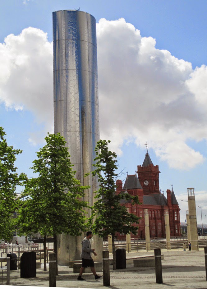 |
| Steel water tower |
We next turned our attention to the
beautiful, gleaming stainless steel water tower (left),
often featured in episodes of Doctor Who and Torchwood.
The tower is shown here with the Pierpoint Building in the
background.
We
passed the National Assembly for Wales building and the Wales
Millennium Center, a 37000 sq meter opera house and performing arts
center. As is true of the water tower, the Wales Millennium Center
marquee appears in numerous Torchwood
and Doctor
Who
episodes as well as several other productions.
 |
| Wales Millennium Center |
Still
making our way to the Doctor
Who
exhibit, we passed the Norwegian Church Art Center. The church was
founded in 1868 by the Norwegian Seamen's Mission. It was
de-consecrated in 1974 and now houses
the Dahl Gallery, hosting contemporary exhibitions of local
photography and art. Just past the church stands the Captain Scott
Memorial. A sculpture erected to commemorate the 1911-13 Terra Nova
Expedition, officially the British
Antarctic Expedition, led by Robert Falcon Scott to the South Pole.
Scott and his four companions did reach the pole, although beaten by
a Norwegian expedition by just 33 days, but perished on the way back
to base. Three of their bodies, along with Journals and photographs,
were discovered eight months later. The photograph of the sculpture
(below)
shows the Norwegian Church in the background.
 |
| The Scott Antarctic Memorial – Cardiff Bay, Cardiff, Wales |
The
surface of the monument is composed of white and near-white tiles
evoking snow and ice. Scott is shown trudging south, leaning as
though pulling a load behind him. The faces of his three companions
are shown trapped in the snow. All five members of the party are
shown in an 18 January 1912 photograph taken at the South Pole.
 |
| Left to right: (standing): Edward Wilson, Robert Scott, Lawrence Oates; (seated): Henry Bowers and Edgar Evans – a public domain photograph |
 |
| Doctor Who Exhibit |
Unfortunately, we
found that the exhibit is closed on Tuesdays, which was today. We
both then retired to the cafe for tea (coffee for Diana), leaving the
Doctor
Who
visit for our return visit to Cardiff.
 |
| Water taxi |
For
the return trip to our hotel we decided to take a water taxi (left)
up the River Taff. The cost was reasonable, the landing was at Bute
Park, just across the street from our hotel, and it would give us a
chance to view the waterfront along the river.
We
had already purchased train tickets for our trip to Newtown the next
day, so we made an early evening of it and, after struggling through
composing a few e-mail messages on my Kindle while Diana watched
programs on hers, we turned in for the night.
 |
| Fruit & Vegetable stand at Cardiff Market |
The
following photograph, taken from the upper level of the structure,
provides a better perspective of the overall market.
 |
| A view of Cardiff Market from the upper level |
Our
next destination was Newtown, Powys County, Wales. This was the area
from which our ancestors originated. Powys County is basically
composed of the territory of the historical counties of
Montgomeryshire, Radnorshire and Brecknockshire. Our ancestor, John
Price, born in 1584, migrated from “Brecknock, Montgomeryshire,
Wales” in the early 1600s and his roots have been traced back to an
earlier John Price who was born in 1494 in Newtown. We just wanted
to get a feel for the area as it exists now. In other words, in what
sort of place would we be living had our forefathers not emigrated to
America.
Our
train trip took us first to Shrewsbury, England (90 miles northeast
of Cardiff) where, after a 37 minute wait, we caught another train to
Newtown, Wales (27 miles southwest of Shrewsbury). We had booked a
reservation for the night at the Dragon Hotel in Montgomery and
planned to make the short eight-mile trip from Newtown by taxi.
We
left Cardiff at 1200 and arrived in Newtown at about 1530. Since the
earliest Prices we know of in our ancestry lived in and around
Newtown, we would spend a little time looking around before we headed
to Montgomery. Our first view was from the train station platform.
 |
| Our first view of Newtown |
The
town looked small and relatively compact, so we set on foot to
explore it. Just down the
street we saw a large four story, red
brick building with a sign (left)
proclaiming it to be the Pryce-Jones Royal Welsh Warehouse. We were
interested because we had learned that some of our ancestors had used
that variation of our surname.
 |
| Pryce-Jones Royal Welsh Warehouse |
 |
| Pryce-Jones Royal Welsh Warehouse |
We
learned that the company, founded by Pryce Pryce-Jones (1834-1920),
was the world's first mail order business. The existing building,
built in 1879, was last used by a call center owned by Shop Direct,
which closed in 201122.
More recently, a large local church has received approval to
temporarily use part of the facility as a place of worship23.
But all this I learned later, so we just snapped one final
photograph (right) to show the
intricately-carved company crest mounted above the main entrance and
continued on our way.
 |
| St. David's Church, newtown |
Leaving
the warehouse behind, we next headed for a large church whose tower
could be seen from the train platform. It turned out to be St.
David's Church (left).
The
church was built in 1847 and continued in service until 2006 when it
closed due to safety concerns. It appeared to be deserted at the
time of our visit; however, according to a 9 December 2010 BBC
report, approval had been granted to convert it into a children's
activity center. We spent some time
 |
| WWI Memorial |
wandering around in the church
graveyard reading the inscriptions on tombstones. We found no Price
graves; however we did note three Price names inscribed on a WWI
memorial (right).
We
next headed toward downtown, but made a wrong turn and wound up on a
picturesque residential street of what appeared to be council houses.
The dwellings were all in a row and each was fronted by a tiny
well-tended garden.
 |
| Residential row houses lining a street in Newtown |
When
we approached what appeared to be the edge of the town without having
seen any sort of downtown, we knew we had gone astray. A kind lady
took the time to set us right and we retraced our path and finally
found ourselves approaching the small, tidy downtown area. Our first
order of business when we got there was to find an ATM, as we were
running short of money. This turned out to be located outside a
service station/convenience store.
Now
having local currency, we headed for a supermarket to purchase
supplies. We bought bread and cheese for our evening meal and then
set out to find a taxi to take us the eight miles to our hotel in
Montgomery. We thought that finding a taxi would be no problem as we
had seen several on the street already and there was a designated
taxi stand in the downtown area. We were wrong. Suddenly, there
were no taxis on the street and the designated stand was vacant.
Just
as we were about to give up on the taxi idea and start considering
other alternatives, we met a very nice gentleman who gave us
directions to the taxi office. He reminded me very much of Onslow,
sister Daisy's husband in the British comedy Keeping up
Appearances, except that he was a lot younger and much better
looking. We thanked him for his help and went in search of the taxi
office, following his directions with care. Alas, we found no such
office.
We
then widened our search by another block in each direction and, much
to our surprise, met “Onslow” again. He again stopped to help
and this time, obviously deciding that the dumb Yanks needed some
hands-on help, offered to lead us to the taxi office. We shortly
arrived back at the spot his original directions had led us to. The
place was deserted, the door was securely locked and there was no
hint that the place served as a taxi office.
“Well”,
said our guide, “They should at least have a sign. But never mind,
my mate Ahmed runs a taxi. He'll take you to Montgomery.”
Whereupon he called Ahmed on his cellphone and after what seemed to
us a prolonged negotiation, informed us that Ahmed would meet us at
the Fish and Chip location just across the street. We decided that
we would have fish and chips while waiting and offered to buy dinner
for our benefactor. He thanked us but said that his wife would
already have dinner prepared and he didn't dare go home having
already eaten.
Ahmed
did show up as scheduled; however, it was obvious that this trip was
not to his liking. In an obviously surly mood, he drove the narrow
winding road to Montgomery at a reckless rate of speed.
 |
| Room at Dragon Hotel |
We
arrived at the Dragon Hotel tired, dirty and a little shaken. It was
a pretty good climb to the attic where our room was located. But we
found the room itself (left)
quite acceptable. Every bit of the limited space had been used to
best advantage. The curtain seen at the end of the room hides an
ample storage area. The room had a radiator for heating and that was
a definite plus; we could drape wet clothing on it for
faster drying.
The bathroom (right),
located to the left, just inside the door and down a step from the
raised sleeping area, was small but well-equipped. It also was
equipped with a heater which meant that we could both dry clothes at
the same time.
 |
| Bathroom at Dragon Hotel |
We
each washed our dirty clothes, taking them into the tub with us when
we bathed. We then rolled our wet garments tightly in towels,
squeeze dried them as much as possible and draped them on the
radiators to finish the process. We then plugged our Kindles and
other electronic devices in to charge and settled in for the night.
Still
familiarizing ourselves with the area where our ancestors lived,
basically the historic county of Montgomeryshire, formed in 1535 and
now part of Powys County, we had arranged for a tour guide to show us
around the local area and then transport us to the city of St David's
on the west coast. Over the years I had seen references to Offa's
Dyke and I knew it was in the general
area, so we started our day
with a quick trip to see a section of it. See the National Path
symbol (left).
 |
| National Path symbol |
The
dyke, a 177-mile long earthwork was reputedly built by King Offa of
Mercia between 757 and 796. However, a recent article on the UK
National Trails Website24
reports that, according to recent carbon dating, at least a section
of the dyke was constructed between 430 and 652. The article
concludes that King Offa probably included parts of an existing
network into the structure he built. The earthwork was apparently
meant to be more a demarcation line than a fortification. A National
Path now runs along the still-visible remains.
 |
| Section of Offa's Dyke |
We
next visited Clun Castle. It wound up on our list because, according
to some accounts, one of our ancestors John Price who was born in
Newtown in 1494, married a Florence Clun in 1509. Of course this
date, if accurate, would mean that he married at age 15.
According
to English Heritage, Clun Castle was originally built by Picot
de Say, one of the Marcher Lords granted lands on the border between
Wales and England by William the Conqueror. It passed to William
Fitzalan by marriage in 1155. It is now owned by the Duke of
Norfolk, a Fitzalan descendant and is under the guardianship of
English Heritage.
 |
| The ruins of Clun Castle |
From
the heights of the ruins, located at the gateway to the Clun Valley,
one has a very fetching view of the village located below.
 |
| The village of Clun seen from the castle ruins |
We
were now beginning to think of the drive across the country and down
the west coast to St David's, Pembrokeshire where we had reservations
for the night. But we did want to stop at Glan Mule (Glanmiheli) and
Abermule, both areas that we had read about while planning our trip.
At
Glan Mule we found a very small village and a large commercial
farming operation at nearby Glanmiheli Bridge.
 |
| Large farm at Glanmiheli Bridge just outside Glan Mule |
Abermule,
just down the road from Glan Mule, turned out to be a slightly larger
village. However, the only thing that captured my attention was the
War Memorial (right) mounted in
the
town square. It included the name of one Price from the area who
died in that war.
 |
| War Memorial at Abermule |
On
the recommendation of our tour guide, we ate lunch at Glansevern
Hall, Welshpool. The location is described as “more
than 25 acres of glorious gardens ... an elegant Greek revival house
on the banks of the River Severn. As well as fantastic lakeside
walks, … a beautiful water garden....”
However, we still had to drive across Wales to the west coast before
the end of the day, so we skipped everything but their excellent
restaurant.
After
lunch we retraced our way through Newtown and then drove on up the
Severn River Valley and then the Wye River before crossing the
Cambrian Mountains and continuing to Aberystwth on the west coast.
From Aberystwth we continued south along the coast through Fishguard
to our destination at St. Davids (note the absence of an apostrophe
in St. Davids; that seems to be standard practice) where we had
reservations at the Grove Hotel. We ate dinner in the hotel
restaurant, caught up on e-mail and turned in for the night.
The
next morning we headed for Dinas Island for a hike. Located along
the coast between Fishguard and Newport, Dinas in not really an
island because it is connected to the mainland by a neck of land. It
includes a working farm and is encircled by a hiking path (or trail).
We drove to a carpark at a beach on the Fishguard side of the island
at Pwllgwaelod, just at the end of the low-lying “neck” that
almost separates the island from the mainland.
Our
guide, still with us for the day, waited at the carpark while we
hiked around the island. The trail from Fishguard Bay to Newport
Bay, climbs to the top of the cliffs and then follows along the
rugged coastline, dipping once to pass near Needle Point Rock, before
it descends to a beach at Newport Bay. The section of trail to this
point is a part of the Pembrokeshire Coast National Trail. The rest
of the circuit around Dinas Island, the connector across the
low-lying “neck” is largely along a paved footpath. The
connector will surely be inundated by even a moderate rise in the sea
level, making Dinas a real island.
From
the carpark, one travels a short distance along the paved road that
leads to the island farm, leaving it to follow the coastal trail
through a pedestrian gate, also called a “kissing gate.” The
flowers along the road were gorgeous and we first continued on the
farm road until we came to a closed gate, finding the banks all along
the way blanketed with bluebells and gorse.
 |
| Bluebells |
 |
| Gorse |
After
we returned to the kissing gate and continued along the trail, we
continued to be surrounded by flowers, among them beardstongue and
rue anemone.
 |
| Beardstongue |
 |
| Rue anemone |
We
climbed over 450 feet from the beach to the top of the cliffs and
from there had great views out across the bay and to the Fishguard,
UK to Rosslare, IE Ferry docked across the way.
Along
the path we saw ancient stone walls that were, in places, topped by
more modern wire fences. We passed through another kissing gate,
passed an Ordnance Survey marker and then came at last to Diana's
primary goal for the hike, Needle Rock, a favorite nesting place for
the guillemots and other birds. We saw a number of these along with
some gulls as we passed by the rock.
 |
| Birds nesting on Needle Rock |
 |
| Needle Rock at Dinas Island |
We
found two very knowledgeable birders perched on the cliff just above
the rock waiting to catch the birds as they rode the breeze in to
land at their chosen nesting spot and Diana stopped for some
pointers. Then, passing on, we found that the best view of the rock
itself (left) was had by looking
back just after we had passed.
 |
| Bluebells and spring beauties |
Just
as were nearing the beach at Newport Bay, we came upon a very
attractive patch of mixed bluebells and spring beauties (right).
It
was now just a short distance back across the neck of the island to
where our guide was waiting and we hurried right along. We had
learned that his mother was in hospital and wanted to let him go in
time to see her that evening.
We
checked into the Y Glennydd Hotel after our visit to Dinas Island
because we had arranged for only one night at the Grove and it was
now booked. We visited the tourist center and walked around in St.
Davids for awhile then visited Saint Davids Cathedral. I had
expected the cathedral to be a ruin; however, we found that it has
been restored and regularly scheduled worship services are held.
 |
| Saint Davids Cathedral from the driveway above |
We
spent some time inside the cathedral, wandering through the bookstore
then, while Diana continued shopping, I just sat for a time to enjoy
the peaceful surroundings. As always in such surroundings, I
wondered what inspired men to build such magnificent structures. I
am sure if asked, the builders would say that it was for the glory of
God. I rather suspected, however, that they confused their own glory
with that of their god. But, on the other hand perhaps the buildings
were useful as public works projects. In any case, Saint David's
Cathedral is a magnificent place and I was quite content to just sit
and enjoy it.
Unfortunately,
I was soon distracted by a, somber, officious looking, man dressed
all in black and pompously wielding a large ring of keys as he rushed
hurriedly about, I left my resting place at the back of the church
sanctuary and moved down a large side hall. There were two of these,
running the length of the sanctuary and beyond, one on either side.
 |
| Sanctuary a Saint Davids Cathedral |
The
large halls on either side of the sanctuary are separated from it by
the huge pillars that form its boundaries as shown above.
 |
| Bishops Iowerth – 1231/ Anselm – 1247 |
 |
| Lady Maidstone - 1932 |
The “Lady Chapel,” shown below, is situated just on the other side of the wall shown behind Lady Maidstone's tomb as seen in the above photograph. Although the chapel does not have her name affixed anywhere that I could see, I assume that it is named in her honor.
 |
| The Lady Chapel, presumably honoring Lady Gladstone whose tomb lies just behind the wall shown at right. |
 |
| Tomb of Edmund Tudor |
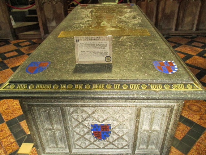
Located
in a place of honor, between the main sanctuary and and the Lady
Chapel, is the tomb of Edmund Tudor (left),
first Earl of Richmond, father of King Henry VII and grandfather of
King Henry III. According to information posted at the tomb, its
presence may be the reason the cathedral was spared physical
destruction during the dissolution of the monasteries under Henry
III.
 |
| Tomb of Rhys Ap Rhys |
The
next tomb (right) is that of Rhys
ap Rhys. He was also known as Rhys Gryg (English Rhys the Hoarse)
and Rhys Fynchan (i.e. The Younger). He was a Welsh prince and ruler
of part of the Kingdom of Deheubarth.25
The
next day, 11 May, was Sunday and we had to check out of the Y
Glennydd Hotel because they were booked to capacity for the rest of
the weekend. The proprietor did, however, manage to book us another
room just down the street at the Glendower Guest House. We slept in
as long as possible without missing breakfast and then checked out,
depositing our bags at the new location.
 |
| Sign at Sounds Cafe |
Later
in the day, feeling a bit restless, I decided to make a short trip
(there are no long trips in St. Davids City) to the Bishops Castle
ruins. I was pretty sure that the large stone ruins we had noted
nearby while visiting the cathedral must be the castle ruins. On the
other hand, the castle was supposed to be across the River Alun and I
had seen no river.
 |
| The River Alun |
The
palace must once have been impressive, but it was now just ruins.
 |
| Saint Davids Bishop's Palace ruins |
The
boat trips to Ramsey Island nature reserve start at St. Justinian's
Lifeboat Station, located 2 miles from St. Davids. We were at the
tour office to pick up our tickets shortly after they opened and the
Loadmaster, a very nice lady, who was just leaving for the dock, gave
us a lift.
 |
| St. Justinian's Lifeboat Station |
 |
| Diana |
On
arrival at the island the boat operator checked to see how many
people wished to book an additional cruise around the island to look
for birds. Alas, not enough people were interested so that part of
the trip was not scheduled. The boat would pick us up where we were
dropped off later in the day. Meanwhile we were left to hike around
the 640 acre nature reserve. A trail circumnavigates the island and
one can hike it either clockwise or counterclockwise. We decided to
go clockwise and set out up the road from the dock to the old
farmhouse where we would start the hike.
 |
| Road leading from the dock up to the old farmhouse on Ramsey Island |
One
of the first sights to greet us as we passed along the trail above
the farmhouse was a grass, bluebell and gorse covered depression
leading down to the shore between us and an ocean bluff ahead. A
small corner of the rock wall enclosing a garden behind the farmhouse
is visible at lower left in the below photograph.
 |
| Bluebells and gorse above the farmhouse on Ramsey Island |
 |
| Ancient stone walls |
 |
| Ordnance Survey marker |
The
highest spot on the island, marked by an Ordnance Survey marker
(left) is on the opposite side from
the farmhouse. A path turns off the main trail and leads directly up
the hill to it. I climbed to the marker because I wanted to check
the view from the highest point. The extra few feet didn't add much
as the view is spectacular from just about anywhere on the island.
 |
| South Bishop Lighthouse |
 |
| Enclosed fields with grazing sheep |
As
we neared the end of our hike we came to a stone wall enclosed field
(left) with several grazing sheep.
According to the preserve, “grazing animals such as sheep,
ponies and deer were introduced onto the island to graze on the
various habitats and keep growth under control.”26
We
were finished with our hike on Ramsey Island but still had a couple
of hours to wait for our boat. We sat at a picnic table in the
farmhouse yard and ate the box lunches we had brought with us. Then
we stretched out in a sunny spot to take a nap. But as the sun
changed position my sunny spot moved into the shade and with a brisk
breeze blowing it soon became quite chilly. I eventually dug out my
plastic poncho, wrapped up in it, and was quite cozy until the boat
arrived.
 |
| Archaeological excavation sign |
As
we headed north on the Coastal Path from Whitesands Beach, we noted
several people digging in a fenced-off area between the trail (path)
and the parking lot. A closer look revealed a sign (right)
identifying the site as an archaeological excavation. As we climbed
the hill we got an overview of the area.
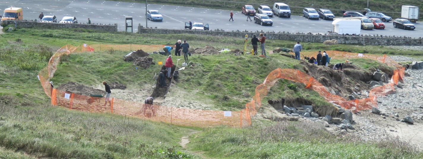 |
| Archaeological excavation |
 |
| Coastal Path just north of Whitesands Beach |
 |
| Wood pigeons |
We
met only a few other walkers along the path. In this part of the
world hikers are “walkers” and trails are “paths.” The
American terms, “trail” and “hiker,” are occasionally used
and are understood perfectly well, but are just not standard
terminology.
 |
| Kissing gate |
The
hillsides along the path were literally painted with spring flowers,
in addition to gorse which we had seen everywhere we went, we saw
beardstongue blanketing a rock wall, a particularly lush clump of the
thrift that covered the banks along the way, a mixture of bluebells
and cowslips and one of heather and thrift.
 |
| Beardstongue |
 |
| Thrift |
 |
| Bluebells and cowslips |
 |
| Heather and thrift |
 |
| Rocky, thrift-adorned slope, sea, islands and sky |
But my favorite view of the day was of a particular rocky, thrift-adorned slope that sported a stretch of sea, some outlying islands and a cloud streaked strip of sky as a backdrop.
When
we arrived at St Davids Head I photographed the
dolmen looking out to sea.
 |
| Coetan Arthur Dolmen at St Davids Head |
 |
| The author at Coetan Arthur Dolmen on St. Davids Point photograph by Diana |
“...
a Cromlech lying on the high ridge of ground north-east of St.
David's Head. It is placed among large masses of rock cropping out
above ground, with others of various sizes which lie scattered on the
surface. The cap-stone, which lies N.W. b. W., is eleven feet nine
inches in its greatest length, and nine feet nine inches in its
greatest breadth, narrowing rather towards the north. Its thickness
does not exceed one foot four inches. Of the supporters, one only
remains standing, which carries the eastern angle of the cap-stone.
Its height is four feet three inches, its main breadth, taken from
north-west to south-east, four feet, and its greatest thickness ten
inches. At the northern angle lies a fallen supporter, five feet in
height; and two stones, which probably played the same part, lie on
the west side, one five feet high, and the other three feet six
inches. The south-eastern end has been built up, and several loose
stones lie to the east of it. The cap-stone was dismounted as early
as the sixteenth century.
Having
seen the dolmen, we left St. Davids Head, returned to Whitesands and
settled in at the cafe for hot drinks while we waited for the bus to
take us back to St. Davids.
 |
| Travellodge and Great Western Pub |
They
did have a room for us, so we promptly checked in and connected to
the internet, something we had been unable to do for the last three
days.
First
thing the next morning we took the bus to Cardiff Bay for the Doctor
Who Experience. After giving the matter some thought, I decided
that, despite having never seen a single episode of the show, I would
go with Diana rather than wait in the cafe. That turned out to be a
good decision as I thoroughly enjoyed it.
The exhibition starts with a short film, followed by a voyage in the Tardis (the blue Police Box space ship the Doctor travels in). Once inside the Tardis, the visitor slips through a time crack and accompanies the Doctor as he uses a sonic screwdriver to escape from his foes. The current Doctor Who is the eleventh to play the role since the show was originated in 1963. Doctor Who is a “Time Lord,” an alien being, who travels around the universe doing good. The change from one actor to another in the lead role is explained as a rejuvenation of the Time Lord. This also allows a different approach to be written into the role for each new actor filling it. In the series, the rejuvenations are made necessary when the Doctor sustains injuries that would be fatal for a mere human.

We
finished our tour of the exhibit with an examination of Bessie
(left),
the Doctor Who roadster.
Our
next stop was to be Cardiff Castle, so we took the water taxi up the
River Taff to the landing at Bute Park, which we would walk through
to the castle, enjoying the scenery along the way.
 |
| The shoreline viewed from the Water Taxi |
 |
| Gorsedd Stone Circle |
This
stone circle is not an ancient monument; it was erected to celebrate
the Welsh National Eisteddfod (a Welsh
festival of
literature,
music
and
performance)
held in the city in 1978. However, I have read that the central stone
slab used in the circle was recovered from an ancient megalithic
monument found nearby.
 |
| Silver leaves at twig tips |
 |
| Corner of Crown Court building and City Hall clock |
For
the most part, we just wandered around and enjoyed the scenery. This
included lamppost sculptures of the Cardiff Coat of Arms, flanked by
two dragons, mounted at the southeast lawn of the Crown Court
building. In the below photograph, the three ostrich feathers at the
top are overlaid by a Tudor rose, the Welch goat at left represents
the Glamorgan Mountains, the sea horse at right represents the Severn
Sea and trade and the dragon in the middle is holding a flag with
three chevrons, attributed to the last Prince of Glamorgan. A leek,
a national emblem of Wales, can be seen just to the left of the
dragon. The words on the banners at the bottom, ‘Y
ddraig goch ddyry gychwyn’, mean “The
red dragon will lead the way.”
 |
| Cardiff Coat of Arms – Crown Court Building in background |
 |
| Red dragon |
Looking
up from the front of the Crown Court building we saw a sculpture by
Paul Rafael Montford titled Commerce and Industry. It included six
life-size figures dressed in classical style to represent various
industries.
 |
| Commerce and Industry – Cardiff Crown Court |
 |
| City Hall clock tower and Poetry and Music sculpture |
The
day was now approaching its end, so we cut short our wandering
through the streets of Cardiff, ate dinner at the Revolution Cafe and
returned to our motel. We wanted to catch up on our e-mail
correspondence and plan tomorrow's trip to the Welch National History
Museum. The museum has relocated old buildings from all over the
country to its site at Cardiff and I particularly wanted to see some
of the structures that existed around the time our ancestors
emigrated.
The
next morning, our last day in Wales, we caught a bus to the museum.
We spent some time in the gift shop and then set out on a self-guided
tour of the facility. We saw old churches, barns, shops, farmhouses,
a mill, a toll house and even a round pig sty. All in all it was a
great way to spend the day, both educational and entertaining. I
would recommend it for the first day of a visit to Wales.
 |
| Gwynned farmhouse |
 |
| St. Teilo's Church |
St.
Teilo's Church (left), originally built in the 12th century,
altered and extended into the 16 century, was re-erected here as it
is believed, based on recovered paintings, to have appeared around
1530.
Replicas
of two of the recovered wall paintings are shown below.
 |
| Wall painting at St. Teilo's Church |
 |
Wall painting at St. Teilo's Church
|
The
farmhouse shown here (below, right) was
built in Gower in 1610 and re-erected in 1955. Originally, the house
consisted only of one room and a loft above. A living room was added
around 1680 and a
kitchen about 1750. The red color may have been
intended to protect against evil spirits or may simply have
demonstrated that the owners were affluent enough to put red pigment
in the whitewash. The white structure adjoining the house at the
rear is a cowshed/barn.
 |
| Gower farmhouse |
 |
| Hand-cranked grindstone |
 |
| Blacksmith shop |
 |
| Circular pigsty |
 |
| Horned black sheep |
We
caught the bus back to town, ate a takeaway dinner in our room and
retired early in preparation for an early departure the next day.
The
next morning our bus to the airport left at 0425. Although our
flight did not leave until 0805, the gate closed at 0740 and we
wanted plenty of time to make our way through security. We were
traveling with no check-in baggage and the Aer Arann regional flight
we would be taking had quite strict carry-on luggage standards. We
would each be limited to one 22" x 16" x 8" bag, weighing
no more than 15 pounds. We both made it, but we had a lot of junk stuffed
in our pockets and under our shirts and, in my case, tucked into a
kangaroo pouch (or, as Diana called it, a “frontal assault pack”).
In Dublin we went through security at least twice, it seemed like more than that, during our three-hour layover. But we finally boarded our United flight for the eight-hour trip back to Dulles. I watched three movies, I know not which ones, during the flight, finishing the last one just before we descended at Dulles, a few minutes before our scheduled arrival time of 1530.
In Dublin we went through security at least twice, it seemed like more than that, during our three-hour layover. But we finally boarded our United flight for the eight-hour trip back to Dulles. I watched three movies, I know not which ones, during the flight, finishing the last one just before we descended at Dulles, a few minutes before our scheduled arrival time of 1530.
We
hired a taxi to take us back to Takoma Park, ordered pizza delivered
for dinner and were soon asleep.
1John Price the emigrant, Jamestown colony 1620, with some of his descendants, by Rev. Benjamin Luther Price, Minister of the First Presbyterian Church, Alexandria, Louisiana, published before 1923, reproduced 2010 and available at Amazon.com
The
next morning Diana
delivered me to Washington National airport for my 0759 flight. I
had a three-hour layover in Newark and was in Phoenix a about 1430.
the Arizona Shuttle then delivered me to cottonwood about 1830
where I was met at the station by Rosemary. I had departed home
on 1 May and it was now 18 May. My Wales trip was over and I
was ready for a couple of days rest.
1John Price the emigrant, Jamestown colony 1620, with some of his descendants, by Rev. Benjamin Luther Price, Minister of the First Presbyterian Church, Alexandria, Louisiana, published before 1923, reproduced 2010 and available at Amazon.com
2
A History of Wales, Rev 2007, by John Davies, Penquin Books, 375
Hudson
Street, New York, NY 10014, USA, page 1
6
A History of Wales, Rev 2007, by John Davies, Penquin Books, 375
Hudson
Street, New York, NY 10014, USA, page 120
10
A History of Wales, Rev 2007, by John Davies, Penquin Books, 375
Hudson
Street, New York, NY 10014, USA, page 27
11
Ibid, page 28
12
Ibid, page 41
13
Ibid, page 43
14
Ibid
15
A History of Wales, Rev 2007, by John Davies, Penquin Books, 375
Hudson
Street, New York, NY 10014, USA, page 62
16
http://www.bbc.co.uk/wales/history/sites/themes/periods/dark_ages04.shtml
17
http://viking.no/e/france/foundation.html
18
A militarized border region
19http://www.bbc.co.uk/wales/history/sites/themes/periods/medieval_normans05.shtml
20
See Appendix
22http://www.bbc.com/news/uk-wales-mid-wales-12299914
23http://www.bbc.com/news/uk-wales-mid-wales-26138359
24http://nationaltrail.co.uk/offas-dyke-path/news/breaking-news-archaeologists-have-uncovered-evidence-which-suggests-offas-dyke-
25http://en.wikipedia.org/wiki/Rhys_Gryg
26http://www.ramseyisland.com/Ramsey%20Island%20rspb%20nature%20reserve%20st%20davids%20pembrokeshire%20wales.html
27A
Google eBook, available at:
http://books.google.com/books?id=IjZVAAAAcAAJ&vq=coetan+arthur&dq=cromlech+at+st+davids+head&source=gbs_navlinks_s
No comments:
Post a Comment